

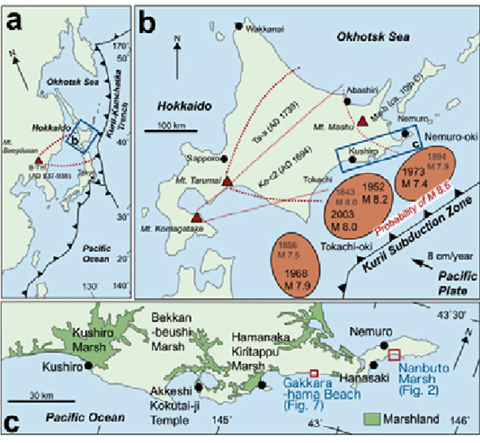
The Shiretoko Peninsula is the NE-most extension of the very volcanic Hokkaido Island. Is it generally parallel to neighboring Kunashir Island, the southernmost of the Kuril Islands, which lies some 30 km SE across the Strait of Nemuro. This is a complex region, as the volcanic front from the Kurils establishes itself in Northern Hokkaido. We have multiple recent calderas on Kunashir Island. No calderas on the peninsula. Closest caldera on Hokkaido is Akan – Mashu some 80 km S.
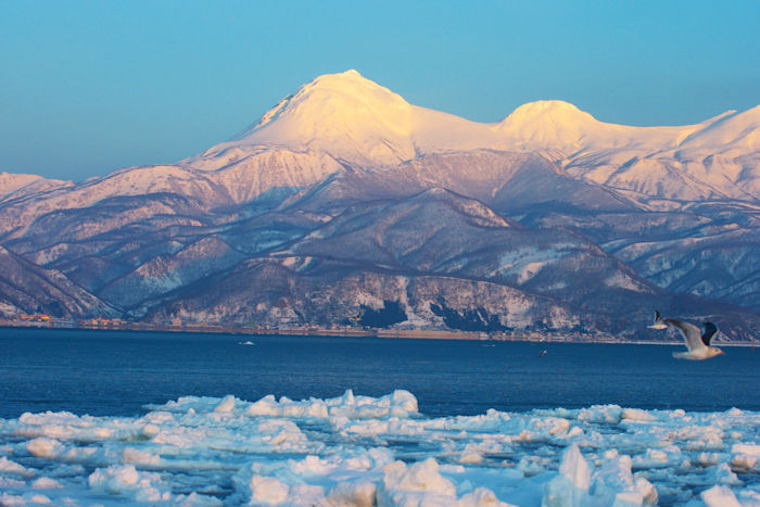
The Shiretoko Peninsula is about 65 km long, with its long axis generally NE – SW. Its area is around 1,000 km2. Volcanoes top out 1,000 – 1,660 m and are aligned with the long axis of the peninsula. Shorelines around the peninsula are steep cliffs 20 – 150 m high.

There is also a network of faults running generally with the long axis of the peninsula through the line of volcanic edifices. Action along these faults has led to at least 645 identified landslides, covering perhaps 10% of the area of the peninsula. There are large landslides that source from high on the volcanic edifices. Smaller landslides are located everywhere. Domes are notoriously unstable, with multiple flank collapses, and debris avalanches.
There are at least 7 volcanoes on the Shiretoko Peninsula. Three of them are listed as active. Two are listed as inactive. Two don’t show up in the Smithsonian GVP database. We will be discussing the three active volcanoes, Shiretoko-Iozan, Rausu and Tenchozan in more detail later in this post.

Total population of the peninsula is in the vicinity of 20,000. Shari is the largest town with 12,000. Rausu is the second largest with 6,000. Yearly visitors to Shiretoko National Park are 1.8 million, with two thirds of them on the N (Rausu) side. Most of the peninsula is only accessible on foot or by boat. Shiretoko-Iozan does get a few climbers, around 600 / year in 2010. Rausu is popular with climbers, 4,600 / year in 2010. Tenchozan does not have hiking or mountain trails. Total number of climbers is unknown, but likely a non-zero number.
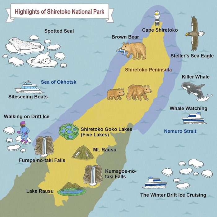
Two notable things about the peninsula are the Shiretoko National Park and the peninsula was registered as a UNESCO World Heritage Site in 2005. It is the southernmost point where sea ice regularly forms in the Northern Hemisphere. The Shiretoko National Park was designated in 1964, containing most of the peninsula. It is managed as a nature preserve and strictly regulated.
The peninsula has short summers and long winters. There are strong subarctic offshore currents which bring in fog and sea ice. The peaks are snow covered Sept – Jun. Some of the highest peaks retain snow all year long.
Volcanic and earthquake monitoring and reporting are done by the Japan Meteorological Agency (JMA). It looks like all three active volcanoes are monitored.

Region
While we will mention volcanoes on the peninsula and across the Strait of Nemuro on Kunashir Island in this section, we will take an expanded look at Shiretoko-Iozan, Rausu and Tenchozan in the next one.
Volcanoes along the spine of the Peninsula from NE – SW include the following:
The andesitic Shiretoko (Shiretoko-dake) is the NE-most volcano in Hokkaido. It was active 600 – 200 ka and is considered as extinct today. There have been no eruptions over the last 10 ka.
Shiretoko-Iozan (Mount Io, Io) is 14 km SW of the extinct Shiretoko along the spine of the peninsula. It has multiple peaks and craters and was active as recently as 1936.
Sashirui is an extinct stratovolcano located between Shiretoko-Iozan and Rausu, 4.6 km SW from Shiretoko-Iozan. It is not listed in the Smithsonian GVP and only shows up as a point on maps in some of the Shiretoko Peninsula papers. It has no reported historic volcanic activity or hydrothermal activity.
The next active volcano is Rausu (Rausudake), located on a ridge 7 km SW of Shiretoko-Iozan. The most recent eruption here took place 1750 – 1850.
Tenchozan is the final recently active volcano in this grouping. It is located some 12 km SW of Shiretoko-Iozan. It was last active nearly 1,900 years ago.
Chinishibetsu is an extinct stratovolcano located some 15.5 SW from Shiretoko-Iozan. It is not listed in the Smithsonian GVP and only shows up as a point on maps in some of the Shiretoko Peninsula papers. It has no reported historic volcanic or hydrothermal activity.
The final volcano on the peninsula is Onnebetsu. Like Shiretoko, it was last active 400 – 200 ka. It is some 20 km SW of Shiretoko-Iozan.
There are at least four other dormant (or extinct) volcanoes in northern Hokkaido (Unabetsu, Shari, Samakkenupuri, Musa) located between the base of the peninsula and the Mashu caldera system. Mashu is some 80 km SW Shiretoko-Iozan.

Across the Strait of Nemuro, on Kunashir Island to the E, we have at least four recently active volcanoes and will list them from NE – SW. Note the volcanoes on Kunashir Island have two names, Russian and Japanese. This is due to shifting ownership of the island in the latter stage of WWII.
The northernmost pair of volcanoes are Smirnov (Ruruidake) and Tiatia (Chachadake) separated by 10 km at the NE tip of Kunashir. The pair is 90 km NE of Shiretoko-Iozan. Smirnov is a highly eroded active volcano. It has lava domes, lava flows, active fumaroles, and pyroclastic cones. Glacial erosion on this volcano exposed its oldest rocks. Tiatia is a symmetrical stratovolcano topped by a 2 km caldera. It appears newer than Smirnov, having not undergone the heavy glacial erosion of its neighbor. It has a young pyroclastic cone in the caldera topped with a summit crater. Fresh lava flows cover much of the caldera floor, overflowing the rim. The cone fills an older somma. The most recent explosive eruption was 1973. There may have been a small, unobserved eruption Feb 2010.
Mendeleev (Raususan) is a volcanic system with at least three nested calderas ranging from 6 km (oldest) to the most recent 1 km diameter caldera. The stratovolcano was breached to the W by a large debris avalanche. Resurgent domes were extruded following the two most recent caldera forming eruptions. The best dated historic eruption was a small phreatic eruption in 1880. There are four solfatara fields on the flanks. There is a geothermal field located outside the caldera along the E coast of the island. This system is located 48 km SW of Shiretoko.
The final neighboring volcano on Kunashir Island is Golovnin (Tomariyama), 41 km SE of Shiretoko. It is a stratovolcano topped with a 4 x 5 km caldera and a crater lake. There are active fumarole areas on the N lake shore, several explosion craters. One of the craters has a hot crater lake that drains through a gap in the caldera wall. Swimming in the lake is prohibited. The only known explosion was a minor explosion in 1848.
Shiretoko-Iozan (Mount Io, Shiretokodake)
Shiretoko-Iozan is another of Japan’s multiple sulfur mountains (Io or Iwo), the source of the name ‘Io’. This one earned its name by ejecting molten sulfur in its most recent eruptions.
The volcano itself is an andesitic, basalt-andesitic volcano that tops out at 1,562 m. It has two large craters at the summit, breached to the NW. The southern crater has a small lava dome. The main cone, Nakadake was constructed NW of the two breached craters. Activity began around 240 ka and continued to the present.
The Shiretoko-Iozan area is composed of andesitic lavas and pyroclastics built upon a base of hyaoclastics and volcanic breccias. Like the rest of the peninsula, it is littered with debris / rock slumps, collapses, landslides, and debris avalanches. These are mainly distributed along the margins of recent lavas and faults that run parallel with the spine of the peninsula through the volcanic edifices. The Shiretokodake Fault runs from N of Mt Uinupuri to S of Shiretokodake. The scarp is 3.4 km long with a maximum height of 35 m. There are multiple smaller scarps 0.4 – 4.6 km long, 2-5 m high displacing recent lava flow planes, domes and crater rims. The Aidomari lava dome is 1 km in diameter and 200 m high. It is cut by a fault scarp 3.4 km long and 35 m high. The eastern half of this dome suffered two large collapsed / debris avalanches. There was also a large slump.
Multiple small collapses and slumps are distributed along the northern extension of the fault. The source area measuring roughly 1.5 x 1.5 km for the Kamiounbe, Kurzurehama and Unakibetsu debris avalanches is located along the northern extension of the fault. Deposits from these avalanches filled valleys 3-4 km long and 400-500 m wide.
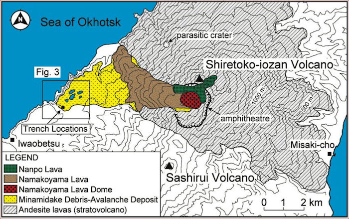
There is a 2 km amphitheater just S of the summit that opens to the W. The Minamidake debris avalanche deposit extends across the amphitheater to the W foot of the volcano. This was a hot collapse, either triggered by a violent eruption or the collapse triggered the violent eruption. The base of the amphitheater is filled with the Namakoyama lava dome, a 1 km diameter, 220 m thick. There is an associate lava flow, Namakoyama lava flow that extends 4 km. The Nanpo lava had 3 lobes, extending NW, W, and S 700 – 1,500 m.
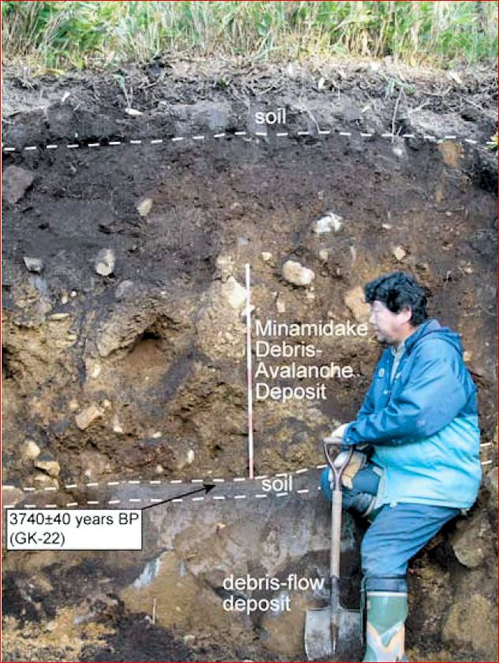
The Minamidake debris avalanche extends to the W 6 km. it is 3 km wide, up to 30 m thick, covering nearly 12 km2. Hummocks are 10 – 100 m across, 5 – 20 m high. The deposit ends in a terminal cliff at the shoreline. It is unclear how much of it ended up in the ocean, although trench sampling documented in the Goto, et al, 2011 paper suggests the flow petered out just before it reached the shoreline. Based on the soil layer immediately below the avalanche, it took place 4.0 ka (2000 BC). There is an earlier debris flow layer in the upper reaches of the coverage area, some 4.3 m thick, that dates around 4.5 ka.

Shiretoko-Iozan is the most active volcano on the peninsula, with at least 7 eruptions over the last 1,200 years (850 AD). The largest of these were a pair of VEI 2 in 1876 and 1889. Everything else was smaller. Eruptions between 600 – 1700 AD were phreatic, ejecting volcanic ash covering the eastern foot of the volcano.

The 5 eruptions in the 19th Century, and the two 1935 – 1936 were all phreatic, from the Chuhuku explosion crater on the NW flank of the volcano. They discharged molten sulfur and hot water that flowed down the Kamuiwakka River to the ocean, covering the beach with yellow sulfur. There are current fumaroles in this crater.
The 1936 cyclic eruption sequence lasted from May – Oct. Typical eruption began with a discharge of molten sulfur, explosive discharge of hot water and steam, intermittent discharge of boiling water and steam, dormant period that lasted until the next explosion.

Rausu (Rausudake)
Rausu is a 1,660 m high andesitic to dacitic stratovolcano. It is currently topped with summit lava domes. There are young lava flows down the NW and SE flanks. An older lava flow traveled 9 km W to the Sea of Okhotsk. There are hot springs at the base of the volcano.
Eruptions from this volcano are quite vigorous, producing tephras and pyroclastic flows. 4 of these in the last 1,200 years, are VEI 3 – 4.
While the intensity of an older eruption some 2,300 years ago (300 BC) is unknown, it did produce at least 6 tephra layers (Ra3 – Ra8 tephras) / pyroclastic flows. Source of this eruption is unknown.
Two eruptions around 1,400 years ago (600 AD) produced large scale Plinian plumes. These are listed as Ra-2 and Rafl-2 eruptions. Tephras reached neighboring Kunashir Island 30 km E. The tephras were followed by explosive eruptions that ejected blocks and at least one pyroclastic flow. This sequence ejected just under 0.01 km3 of pyroclastic fall, a VEI 4.
The 1350 AD eruptions produced Ra-1 and Rafl-1 tephra and pyroclastic flows. Magma volume was nearly 0.02 km3, a VEI 3.
The most recent eruption around 1800 AD produced a pyroclastic flow that covered a 1739 AD tephra from Tarumai volcano in SW Hokkaido.
There was an earthquake swarm in 1964 that damaged a local building. The largest of these was a M 4.6 in Jan. January was the worst month with over 160 quakes recorded. This tapered off quickly in subsequent months with only 3 in Mar.
Similar to neighboring Shiretoko-Iozan, the Rausu area has the same unstable cone and the same problem with multiple collapses, slumps and debris avalanches. Large collapses and slumps are scattered along the valley walls on the SE side of Mt Okkabakedake, Mt Sashiruidake, Mt Mitsumine and Rausu. Distinct faults in this part of the peninsula, Iwozan-Rausudake Faults, lava flows and domes are well preserved on the summits and flanks of Okkabakedake to Rausu. Fault scarps are up to 2.3 km long and 2-15 m high, generally parallel with the long axis of the peninsula.
There was a landslide on the eastern flank of Rausu in 2015. The landslide removed a 380 – 260 m2 area to a depth of 15 – 30 m, entering the sea. Coastal seafloor was uplifted above sea level. Local geology in the area has a base of shale overlain with thick tuff layer. The tuff layer probably was the slip surface of the landslide. The landslide took place in April, likely triggered by melting of 35 cm snow cover over the previous 3 days. This provided plenty of water for lubrication. There was also a local snow dump located on what eventually broke loose. The landslide showed up as seismic events documented by seismometers installed to monitor the nearby volcanoes. The landslide proceeded in two steps; minor followed by major. Both movements uplifted local sea floor a bit. Sea floor just offshore is a meter or two deep. Both movements showed up seismically.

Tenchozan
Tehcnozan is the southernmost of the string of three recently active volcanoes on the Shiretoko Peninsula, some 12 km SW from Shiretoko-Iozan, 4.5 km SW from Rausu. It tops out at 1,046 m, 300 m above the surrounding mountains. The volcano is constructed mainly from andesitic lavas, measuring 4 x 2.5 km, with the long axis E-W. The volcano has fresh lava surfaces.
It has multiple craters aligned in at least three crater chains arrayed on either side of the summit, Northern, Southern and an unnamed third chain stretching to the SW. The chains stretch 1,800 m, number at least 15 overlapping explosion craters no larger than 250 m in diameter. The crater shapes are uneroded, suggesting that they are relatively recent. This eruption produced pyroclastics. Total volume of the VEI 3 sequence is less than 0.01 km3.
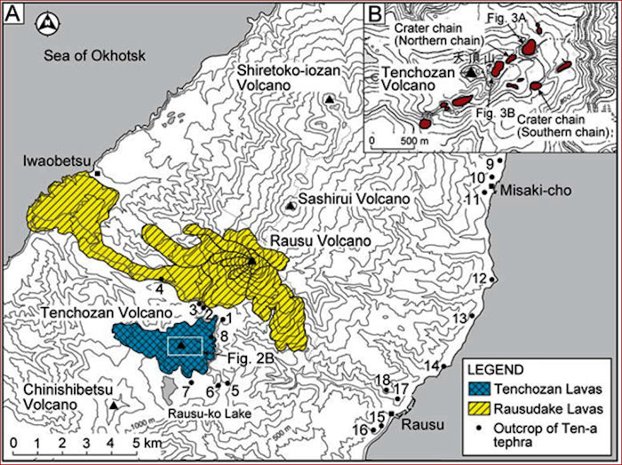
The craters are 20 – 30 m deep with no active fumaroles. There is no historic records of volcanic activity from these craters. On the other hand, they appear to be the source of the most recent Tenchozan eruption some 1,900 years ago.
The 100 AD eruption started with phreatic explosions. The sequence ended with a phreatomagmatic eruption or a small magma eruption. The chains of explosion craters topping the volcano are considered to be caused by this eruptive sequence which ended up being a VEI 3. There are currently no fumaroles observed on Tenchozan. Writeups about the volcano do not mention any active hydrothermal springs, mudpots, or emissions from Tenchozan.

The Ten-a tephra is a 50 cm thick, pale brown, massive pyroclastic deposit. It contains lithic fragments, pumice and ash. Lithics are nearly 30% of the tephra. Chunks measure up to 8 cm. Pumice accounts for 10-15% of the tephra, increasing in proportion toward the top of the tephra. Ash accounts for 60% of the tephra.
Being so close together, deposits from neighboring volcanoes are interlayered. In the area between Tenchozan and Rausu, the Ten-a tephra covers the reworked Rausudake pyroclastic flow deposit, Rausudake lavas and debris avalanche material. Soil dating of buried soils underneath the Ten-a tephra show that soil to be at least 1,900 – 2,300 years old, meaning the tephra must be younger.
Tectonics
We covered the tectonics of Hokkaido in multiple posts, Miss Akan, Toya Caldera, Mashu Caldera, Kutcharo Caldera, Akan Caldera and Tokachi. Granyia’s Miss Akan is probably the best starting point for further reading.
The Kuril and Honshu volcanic arcs join in Hokkaido. This joining controls location of recent volcanic activity in Hokkaido and surrounding areas. 36 volcanoes (or volcanic groups) have erupted in Hokkaido, most of them through central eruptions. Some of these built large caldera systems. Volcanic vents cover 20% of Hokkaido. Pumice and flow deposits cover almost 50%. Most volcanic rocks are basalt – andesite – dacite – rhyolites.
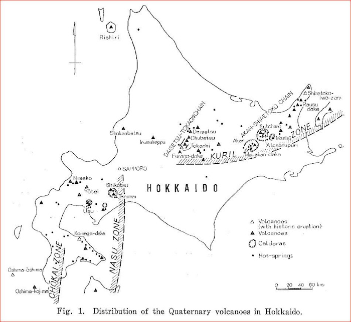
Most of the volcanoes in Hokkaido are arranged in two groups, those belonging to the Kuril Arc and those belonging to the Nasu / Chokai zones. The Kuril arc has two components: Shiretoko – Akan and Daisetsu – Tokachi in central Hokkaido. In western Hokkaido, volcanoes are arranged in two parallel zones, the Nasu and Chokai. There are a few volcanoes scattered outside the two zones.
The Akan – Shiretoko volcanic chain consists of nine andesitic stratovolcanoes and three calderas. It extends 200 km SW – NE, at a shallow oblique angle to the Kuril Trench. Activity along the chain began some 4 Ma at Akan on the SW end of the chain and systematically spread NE. Distribution of volcanoes along the chain is explained by an anticline progressing NE, uplifting the area from submarine to subaerial. This was likely due to deformation of the SW end of the Kuril arc, SW migration of the Kuril forearc sliver around 1 Ma.
Conclusions
Volcanic activity in the Shiretoko peninsula has been vigorous over the past 1 Ma. There are three currently active systems in the center of the peninsula, two of them with active hydrothermal systems. The biggest current threat from stratovolcanoes along the peninsula are some combination of flank collapses, slumps, landslides, debris avalanches. Any volcanic activity will only make these events more common. Fortunately, the region is sparsely populated.
Additional information
Shiretoko-Iwo-zan, Volcano World, Oregon State University, July 2011
Shiretoko National Park, NASA Earth Observatory
2. Rausudake, National Catalogue of the Active Volcanoes of Japan (Fourth Edition, English version)
3. Tenchozan, National Catalogue of the Active Volcanoes of Japan (Fourth Edition, English version)
A fallout tephra from Tenchozan volcano, Shiretoko Peninsula, Hokkaido, Japan, Y Goto, Sept 2011


